The Clutha River or Mata-Au, often referred to as the Mighty Clutha, runs from Lake Wanaka through Central Otago, on through the Clutha District via Clydevale and Balclutha, and then down to the South Coast via Inch Clutha (338 km total). There’s an interesting photo of the Mata-Au meeting the ocean featured in Te Ara : The Encyclopedia of New Zealand.
Earlier today we got close to the Mata-Au at Horseshoe Bend near Millers Flat at the southern end of Central Otago.
From the highway we crossed the Clutha River at Millers Flat and stopped for refreshments at Faigan’s Cafe. The road to Horseshoe Bend is initially sealed and then becomes a narrow dirt/gravel road.
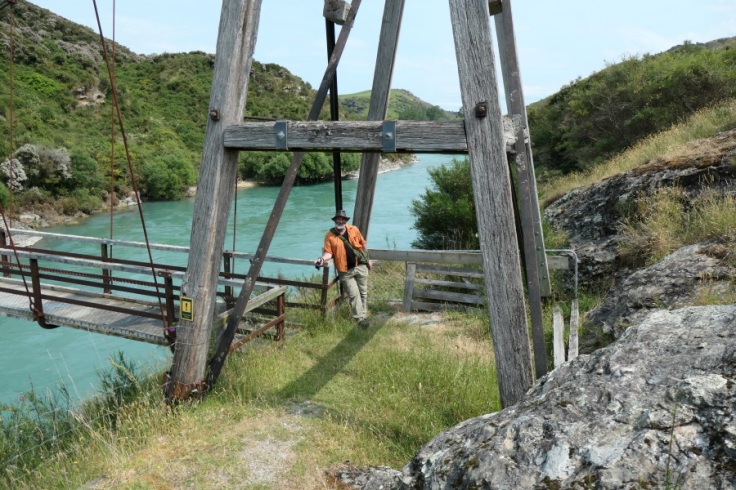
Interesting entry gate from the carpark. It’s a bit of a walk to the bridge. Nigel.

Horseshoe Bend bridge, completed in 1913. Nigel.

Prior to the bridge, access to the outside world was via small boats, punts or cable-chair. Nigel.

It was used by children going to school at Raes Junction and to carry stock from Beaumont Station. Liz.

Horseshoe Bend was once a busy goldmining community with a population of several hundred. This was in 1863 at the height of the early gold rushes. By 1865 the population was 72. Gold continued to be mined into the early 1900s. By 1900 the permanent population had declined to about 30. Liz.
Clutha River view, same as behind Nigel, looking upstream toward Central Otago. Nigel.

For many years the only way people could cross the river was by small boat, or walking or riding to Millers Flat or Beaumont where there were ferries. Liz.

A ‘wire’ was built in 1887. This was a chair suspended from a wire cable and attached to an endless rope which allowed the passenger to pull themselves across the river. There were soon complaints. One end was higher than the other, making it hard for children to pull themselves “uphill”. It was 75m above the river which may explain why when the councillors and county engineer inspected the wire, none of them had the courage to use it! Over the years the chair was shifted twice in an attempt to make it easier to use but in 1907 it was in a bad state of repair and the council was asked to replace it. Liz.

Downstream view, Clutha flowing in the direction of Beaumont. Liz.

This bridge was eventually opened in 1913. The bridge is 70.2 metres long and the towers at either end are 9.3 metres high. Extensive use of railway irons was made in the bridge construction. The bridge is now nationally recognised as a significant heritage engineering structure.
Information I’ve shared here about the history of the bridge and the area is selected from information signs at Horseshoe Bend that I took photos of.
At the far end of the bridge you can see that there are trees with blossom. These appear to be native kanuka or Kunzea ericoides. Here are a couple of photos I took of the blossom from the bridge.


After a while a couple arrived with their young son and also crossed the bridge and we reciprocated taking photos of each other. Here’s the photo of us …

This is my last post for 2019. We wish you all a very happy NEW YEAR !!
Text by Liz, photos by Liz and Nigel; Exploring Colour (2019)

Happy New Year, Liz and Nigel.
LikeLiked by 1 person
And the same to you Mike! A brand new year, a brand new decade 🙂
LikeLike
Thanks, Liz. I still have almost three hours to go before the start of the new year/decade. It’s nice to start out with a whole new calendar, with lots of boxes that I hope to fill with new adventures.
LikeLiked by 1 person
Yes it is! I love the wonderful ‘boxes’ analogy, I hope one of them is labelled ‘New Zealand’ 🙂
LikeLike
I have already purchased the Lonely Planet guidebook for New Zealand and it is high on my list of possible destinations. I was a little shocked to see from your recent posts how much you have been affected by the wildfires in Australia.
LikeLiked by 1 person
The way twitter erupted this morning with lots of people in the south posting photos of the ‘weird sky’ I think we all got a shock! Don’t feel obliged but you might like to take a peek at my Twitter a/c where today I’ve shared some other people’s tweets that show Aussie effects on our landscape and skyscape – you might find it interesting. At https://twitter.com/ExploringColour
LikeLike
Thank you very much for this and for all your little bits of New Zealand. And, what a handsome couple! Have a wonderful 2020.
LikeLike
You are very kind and I’m glad you enjoy what I share about the south of New Zealand. Happy New Year 🙂
LikeLiked by 1 person
That wire/chair arrangement sounds scary – there must have been kids who dreaded it! Lovely pic of you and Nigel at the bridge – Happy New Year to the two of you! 🙂
LikeLiked by 1 person
Happy New Year to you too! I know one place in Central Otago where there still is a wire/chair across a gorge. Have no idea if it’s in working order – just might be as there’s an old tiny cottage on the other side of the gorge as well. I can’t imagine entrusting myself to such a contraption!
LikeLiked by 1 person
I’ve enjoyed learning about NZ through your posts this year, best wishes for the new year!
LikeLiked by 1 person
Thank you Robert.. Happy New Year!
LikeLike
Fascinating. I sort of wish that the ‘wire’ chair was still there, though I wouldn’t have fancied using it! Having said that, the 1913 bridge that replaced it has a lot of character and makes a good photo. The kanuka is also rather attractive. Happy New Year to you both!
LikeLiked by 1 person
As I’ve just written to Ann Mackay in these same Comments I know of a wire chair in Central Otago that crosses a gorge and there’s a tiny old cottage on the other side. No idea if the ‘wire’ is still in working order. Happy New Year!
LikeLiked by 1 person